Old Map of New Milford, Connecticut by USGS, 1955 – Candlewood Lake & Housatonic River
Old Map of New Milford, Connecticut by USGS, 1955 – Candlewood Lake & Housatonic River
✅ Made In USA
✅ Quick Delivery
✅ Cruelty Free
BUNDLE & SAVE
BUNDLE & SAVE
Couldn't load pickup availability
-
Ordered
- - -
Order Ready
- - -
Delivered

Old Map of New Milford, Connecticut by USGS, 1955 – Candlewood Lake & Housatonic River
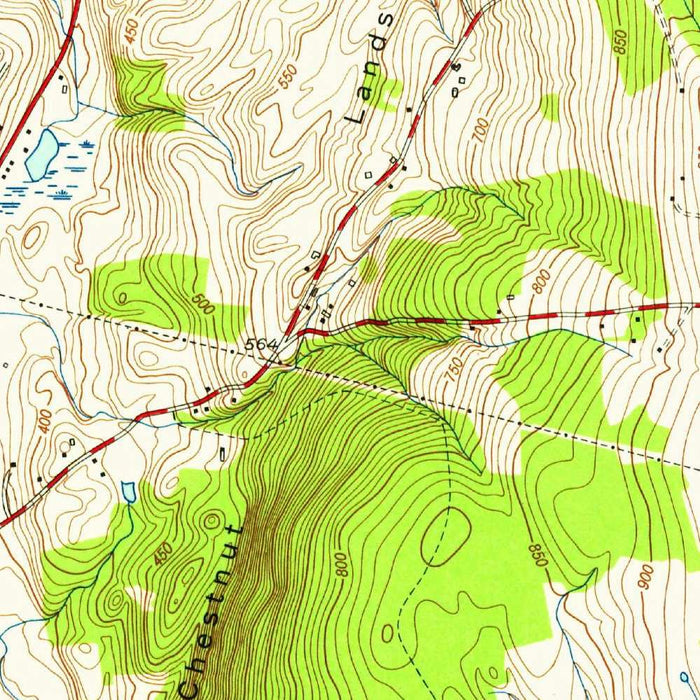
Published in 1958 from 1955 survey work, the United States Geological Survey’s “New Milford” presents a finely measured mid-century portrait of western Connecticut at the precise 1:24,000 scale. Centered on the historic town of New Milford, the map situates the community within a varied landscape of ridges, valleys, roads, waterways, and rural settlements. Its title is elegantly spare, in the USGS tradition, yet the sheet itself is richly informative: a disciplined topographic record of a region where village life, agriculture, woodland, and water all meet. Created during a period of expanding postwar infrastructure and suburban influence, it captures the area before later development reshaped many roads, shorelines, and open lands.
The cartographic language of the USGS is especially compelling here. Contour lines sweep across the sheet in close, expressive intervals, revealing the steep hills and folded valleys that define the Connecticut uplands. Water is clearly distinguished from wooded terrain, roads, and built areas through the practical but handsome color scheme characteristic of mid-twentieth-century American topographic mapping. The result is both scientific and atmospheric: every slope, streambed, and reservoir is made legible, while the broader character of the region emerges at a glance. Around New Milford, the terrain rises and falls dramatically, reminding the viewer that this is not a flat New England village landscape, but a rugged river country shaped by geology, water, and settlement.
The Housatonic River is one of the defining presences on the map, threading through the region and anchoring New Milford’s historic relationship with transportation, industry, and agriculture. Nearby Lake Lillinonah and Candlewood Lake add striking hydrological interest, reflecting the engineered and natural waterscapes that became central to recreation and development in western Connecticut. Reservoirs, smaller lakes, brooks, and wetland margins further enrich the sheet, giving a sense of how water structured both movement and settlement. These waterways were not merely scenic features; they influenced mill sites, road alignments, bridges, farmland, and later leisure communities. In this map, the viewer can trace the dialogue between natural drainage patterns and human adaptation.
The surrounding towns and localities—Bridgewater, Sherman, and the northern reaches toward Danbury—place New Milford within a wider regional network of small communities, farms, wooded hills, and connecting roads. Route 7 and Federal Road appear as important corridors, while local roads and trails weave through more intimate rural terrain. The map’s details suggest a landscape in transition: still deeply rural in many respects, yet increasingly connected to the automobile age and the expanding orbit of metropolitan Connecticut and New York. Parks and recreational areas point to the growing appreciation of the region’s outdoor character, while the road network shows how mid-century mobility was beginning to reshape older patterns of town and countryside.
As a work of the United States Geological Survey, this map belongs to one of the great mapping enterprises of modern history. The USGS brought rigorous field survey, standardized symbols, and national ambition to the depiction of American terrain, producing maps that served engineers, planners, scientists, hikers, landowners, and local governments alike. “New Milford” is valuable not only for what it shows, but for when it shows it: a 1950s snapshot of a Connecticut landscape before subsequent decades of subdivision, environmental regulation, infrastructure change, and recreational development altered its appearance. It preserves the relationship between town, river, ridge, lake, and road with clarity and authority, making it a fascinating historical document of place.
Cities, towns and places on this map
- New Milford
- Bridgewater
- Sherman
- Danbury
- Lake Lillinonah
- Housatonic River
- Candlewood Lake
- Federal Road
- Route 7
- Various local roads and trails
- Parks and recreational areas
- Reservoirs and lakes in the vicinity
Historical context & cartographic details
- Produced by the United States Geological Survey (USGS)
- Historical 1:24,000 topographical map of New Milford, Connecticut and the surrounding area
- Dated 1955 and published with a 1958 imprint
- Uses color to distinguish terrain types, including water bodies, forests, and elevations
- Features detailed contour lines showing the region’s steep hills and valleys
- Reflects a mid-20th-century view of the area, offering insight into land use and geographical change since publication
Looking for a particular place? Review the detailed images to confirm that the town, landmark or feature you have in mind appears on the map. If you are unsure, ask our workshop to check before you order.
Detailed maps are especially rewarding at larger sizes, where names, boundaries and decorative features have more room to be appreciated. Use the close-up preview and size guide to choose the right scale for your wall.
This map looks amazing at sizes all the way up to 50in (125cm). If you are looking for a larger map, please get in touch.
The model in the listing images is holding the 16x20in (40x50cm) version of this map.
Where personalisation is available, you can add a short title or dedication, mark one meaningful place, or request one considered visual detail. See personalised map examples.
Every piece is printed to museum-grade archival standards using fade-resistant pigment inks on acid-free matte paper. Choose an unframed map print, framed map or canvas using the finish options above. Framed maps use crystal-clear optical acrylic and arrive ready to hang.
With its rich detail and strong sense of place, this map makes a considered gift for a new home, anniversary, retirement or anyone with a personal connection to the area shown. Still deciding? Explore our collection of rare old and vintage maps to discover another place, period or style.
Collapsible row
Collapsible row