Old Map of Guilford, Connecticut by USGS, 1893 – Madison, Long Island Sound & Hammonasset Beach
Old Map of Guilford, Connecticut by USGS, 1893 – Madison, Long Island Sound & Hammonasset Beach
✅ Made In USA
✅ Quick Delivery
✅ Cruelty Free
BUNDLE & SAVE
BUNDLE & SAVE
Couldn't load pickup availability
-
Ordered
- - -
Order Ready
- - -
Delivered

Old Map of Guilford, Connecticut by USGS, 1893 – Madison, Long Island Sound & Hammonasset Beach
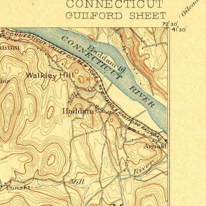
Published in 1904 from survey work completed in 1893, the US Geological Survey’s “Guilford” presents Connecticut’s central shoreline with the precision and restraint that defined early federal topographic mapping. At a scale of 1:62,500, it captures Guilford, Madison, and their coastal surroundings at a moment before the fuller suburban transformation of the twentieth century. The map’s elegant network of contour lines models the low hills, shallow valleys, and rolling uplands behind Long Island Sound, while blue-printed rivers, marshes, and inlets articulate the watery edge of the Connecticut coast. Roads and rail lines thread between village centers, shore communities, farms, and wooded elevations, offering a finely observed portrait of movement, settlement, and terrain at the turn of the century.
The US Geological Survey, founded in 1879, brought a new scientific rigor to American cartography, and this map is an excellent example of its early topographic style. Rather than emphasizing decoration, the sheet derives its beauty from disciplined clarity: measured contours, carefully differentiated hydrography, and a balanced presentation of natural and human features. The map belongs to an era when the federal government was systematically documenting the nation’s landforms, resources, transportation corridors, and settlement patterns. In Connecticut, where colonial towns, tidal rivers, glacial hills, and maritime industries coexisted in close proximity, this work was especially revealing. “Guilford” translates a complex coastal landscape into a readable scientific image, preserving both the measured landscape and the priorities of modern mapping at the dawn of the twentieth century.
Guilford itself anchors the map, a historic shoreline town whose green, roads, and nearby waterways reflect centuries of settlement along Long Island Sound. To the east, Madison appears with its own village center, including Madison Green, set within a landscape of roads, streams, and gently rising ground. The East River and West River structure the geography around Guilford, flowing south toward tidal waters and helping define the lowlands, crossings, and settlement routes. Along the coast, Pine Orchard and Stony Creek evoke the small maritime communities, summer colonies, quarries, and harbors that shaped this part of Connecticut. The map records these places not as nostalgic landmarks, but as living components of a working shoreline connected by rail, road, river, and sea.
The coastal portion of the map is particularly compelling, with Long Island Sound forming the broad southern boundary and giving context to every creek, cove, and settlement along the shore. Hammonasset Beach, now strongly associated with recreation and conservation, appears within a landscape still governed by tidal flats, shoreline approaches, and sparse development. Stony Creek and Pine Orchard suggest a coastline of sheltered waters and rocky promontories, while inland elevations such as Turkey Hill reveal the glacially shaped relief that characterizes southern Connecticut. The contour work is subtle but expressive, showing how modest hills and valleys influenced routes, farms, drainage, and village placement. In this way, the map captures both the maritime face and the interior structure of the region.
As a historical document, “Guilford” offers a rare view of the Connecticut shore before highways, dense residential growth, and modern land-use patterns reshaped the landscape. Its roads and rail lines show the essential transportation framework of the period, linking town centers and shoreline communities while preserving the slower rhythm of rural and coastal life. The map also invites comparison with the present: fields have become neighborhoods, quiet routes have widened, and once-isolated shore places have taken on new identities. Yet the enduring geography remains visible—the rivers still drain toward the Sound, the hills still rise behind the coast, and the old town centers remain legible. This is a refined cartographic record of place, change, and continuity.
Cities, towns and places on this map
- Guilford
- Madison
- Long Island Sound
- Hammonasset Beach
- Stony Creek
- East River
- West River
- Turkey Hill
- Pine Orchard
- Madison Green
- Small hills and marked terrain features
- Roads and rail lines showing connectivity and transport routes
Historical context & cartographic details
- Published by the US Geological Survey
- Survey data was captured in 1893
- Published in 1904
- Historical 1:62,500 topographical map of the Connecticut shoreline
- The US Geological Survey, established in 1879, played a crucial role in scientific research and national mapping
- Features intricate contour lines showing elevation changes
- Water bodies are printed in blue, a typical characteristic of USGS maps from this era
- Shows varied elevations, valleys, waterways, and coastal topography
- Reflects historical geographic data before later urban development, land-use changes, and population growth
- Provides a record of settlements, transport routes, and natural landscape features at the turn of the twentieth century
Looking for a particular place? Review the detailed images to confirm that the town, landmark or feature you have in mind appears on the map. If you are unsure, ask our workshop to check before you order.
Detailed maps are especially rewarding at larger sizes, where names, boundaries and decorative features have more room to be appreciated. Use the close-up preview and size guide to choose the right scale for your wall.
This map looks amazing at sizes all the way up to 50in (125cm). If you are looking for a larger map, please get in touch.
The model in the listing images is holding the 16x20in (40x50cm) version of this map.
Where personalisation is available, you can add a short title or dedication, mark one meaningful place, or request one considered visual detail. See personalised map examples.
Every piece is printed to museum-grade archival standards using fade-resistant pigment inks on acid-free matte paper. Choose an unframed map print, framed map or canvas using the finish options above. Framed maps use crystal-clear optical acrylic and arrive ready to hang.
With its rich detail and strong sense of place, this map makes a considered gift for a new home, anniversary, retirement or anyone with a personal connection to the area shown. Still deciding? Explore our collection of rare old and vintage maps to discover another place, period or style.
Collapsible row
Collapsible row